


 to Your Door")


- One of the main challenges that comes with analyzing satellite images is establishing whether a change in land use has taken place legally or illegally.
- A recent study, published in Nature magazine, used a new methodological approach that allowed the researchers to identify which areas had undergone illegal changes in land use between 1984 and 2019.
- Deforestation for the creation of pasture for illegal cattle ranching has seen an unprecedented, exponential increase since 2017.
- The researchers also said there is a good chance of restoring forest cover in areas that were once used for coca farming, meaning it would avoid the same fate as forested land that has been lost to illicit cattle ranching.
An innovative new study featuring the methodological use of machine learning algorithms, published in Nature magazine, has revealed that more than 3 million hectares (7.4 million acres) of Amazonian Rainforest were cut down to make way for illicit activities between 1985 and 2019. The results of the analysis of the 34-year time frame showed that “the vast majority of deforestation … is attributed to stable cattle ranching lands.”
The study, published in February, illustrated how the loss of forest cover to make way for grazing pastures for cattle ranching has increased exponentially since the Peace Agreement between the Revolutionary Armed Forces of Colombia (FARC) and the Colombian government in late 2016. “The agreement indicated the end of FARC-led gunpoint conservation. It signaled the beginning of new land use activities such as cattle ranching, promoted by drug cartels and large landowners seeking to capitalize on more favorable land policies,” the study said.
Identifying areas of rainforest cut down for illegal activities
One of the main obstacles that scientists and decision-makers have faced when using satellite images to analyze changes in land use is the difficulty of accurately establishing when this change took place illegally. This is because those involved in illegal activities deliberately work to cover their tracks, with this being compounded by the fact that illicit activities are not well documented in publicly accessible data, making it difficult to connect them to land cover changes observable by remote sensing. “Illicit activities may exhibit landscape patterns similar to those of legitimate activities, making it difficult to detect and differentiate illicit activity from other land-use types,” the report stated.
The study’s main author, Paulo Murillo-Sandoval, who has a PhD in geography and is a professor at the University of Tolima in Colombia, said that pastures for livestock and other crops look the same when viewed from Landsat satellites in space. “I could show you a coca field and a field for grazing and you wouldn’t be able to see the difference,” he said.

One of the main contributions to the researchers’ analysis, which helped provide more detailed data about the illegality of the activities in question to be obtained, was the use of deep learning algorithms that were trained to identify very specific data to a high degree of accuracy.
“These new algorithms are able to learn not only from the pixels themselves, but from what is around the pixels and from the shape of deforested land patches. For example, you can feed the algorithm relevant information; for example, that cattle ranching uses up very large and very regular [symmetrical] tracts of land. The system learns this and is then able to differentiate it,” Murillo said.
The researchers’ aim was to understand how illegal activities accelerate changes in land use, and in order to do so they analyzed three common scenarios in the Colombian Amazon. The first looked at the presence of coca cultivation on the same patches of land over time; the second at changes of land use from coca cultivation to pasture for cattle ranching and the third at land cover changes from forest cover to pasture for cattle ranching.

The results showed that between 1984 and 2019, “The forest to cattle conversion pattern was especially pronounced outside the agricultural frontier [established by the Colombian government in 2018],” the article states. The frontier represents the areas where agricultural and livestock activities can be carried out once legal permits have been applied for. Outside these areas, such as in protected areas and the deepest regions of the Amazon, such activities are considered illegal.
The study found that the forest to cattle ranching pasture conversion pattern was particularly pronounced outside this frontier — or, put another way, in prohibited areas. “In Colombia, forest conversion to cattle ranching serves as a mechanism for legalizing informal or illegal landholdings. … Small farmers see cattle ranching as a safe investment that provides a quick return or as a buffer during economic uncertainty,” the study highlighted.

The impacts of cattle ranching on the Amazon
One of the scenarios analyzed by the researchers in the Amazon region was the shift from coca cultivation to pasture for cattle ranching.
The article highlighted three possible causes for this transition. Firstly, the expansion of the road network by approximately 200 kilometers (124 miles), carried out by the FARC during the most difficult years of the armed conflict. This resulted in an increase in the commercialization of land and motivated stakeholders to expand logging activities. Secondly, agrarian policies that incentivized legal ownership of land were conditional on “land productivity,” with cattle ranching becoming the easiest and most efficient way to demonstrate such productivity. Thirdly, income from coca production allowed farmers to acquire then gradually merge together abandoned plots of coca fields, eventually converting them into pasture.
Murillo said the amount of land converted from coca cultivation to cattle ranching pasture over the 34-year study period was less than 4,000 ha (9,900 acres). These figures “strongly challenge popular narratives that cattle ranching is a common strategy for legitimizing coca plots.” The results of the study decisively showed that most deforestation — approximately 3 million hectares in little more than three decades — was due to the direct change from forested land to cattle ranching pastures.


In an attempt to justify the theoretical legality of cattle ranching, many politicians and landowners in the Colombian Amazon have claimed that the activity was established in areas where coca cultivation had already caused deforestation, but that the cattle ranching industry was not directly involved in the logging of the rainforest. In other words, they claimed that coca cultivation was the main activity responsible for deforestation in the Amazon.
In fact, in 2018, when former Colombian President Iván Duque was running for another term in office, he claimed that “coca is the greatest destroyer of rainforests in Colombia, and this debate about the environmental damage caused by coca seemed to be absent in the great environmental debate in the country.” Two years into his presidency, his discourse on the issue started to change and he would frequently announce that he would continue to fight against illegal logging and mining, drug trafficking and unauthorized land clearing for cattle ranching, which all contributed to the destruction of the environment.
“We have to try a little to change this conventional narrative that coca is the main driver of deforestation in the Amazon,” Murillo said.
The article in Nature magazine also highlighted that farmers invest in cattle ranching as a way of securing subsequent claims to the land, which also allows them to launder and cover up income generated from drug trafficking.
Furthermore, the study expressed concern over the situation in Colombian national parks such as the Sierra de la Macarena, Tinigua and La Paya and in the Nukak National Nature Reserve. “Protected Areas remain havens for both coca and new cattle consolidation lands. … The direct conversion from forest to cattle has irreversible consequences for pristine forests in Tinigua and Macarena.”
Recently, Liliana Dávalos, a Colombian biologist and professor at Stony Brook University in New York, told Mongabay Latam that there are “huge environmental footprints” in the Colombian Amazon. “These are the [cattle ranching] pastures and these pastures exist not because there is a strong market for cattle ranching, rather because they are associated with land appropriation. It’s not that there is an irresistible demand for cattle, meat or milk products, rather that with the cattle come rights and traditions that are to do with land.”
Since Colombia went through a failed peace process with the FARC more than 20 years ago, during the government of Andrés Pastrana, Dávalos has been investigating how a possible post-conflict scenario could negatively affect Colombia’s forests.
According to the investigation led by Pablo Murillo, the forest to cattle ranching pasture conversion patterns in the Tinigua National Park have shown how old and new farmers have fragmented and appropriated land in the area with the backing of FARC dissidents and large-scale cattle ranchers.
“Certain ‘rules’ have been followed by the new groups that are now operating in the Amazon, such as filling the southern part of Tinigua National Park with cattle ranching activities and preserving the northern part in order to ensure their mobility through the park,” Murillo said.
Although it was not one of the scenarios analyzed in depth in the scientific study, the researcher emphasized that “there are many abandoned areas that once had coca fields and now have secondary forests. This, for example, is an opportunity to consider for possible conservation strategies in the future.”
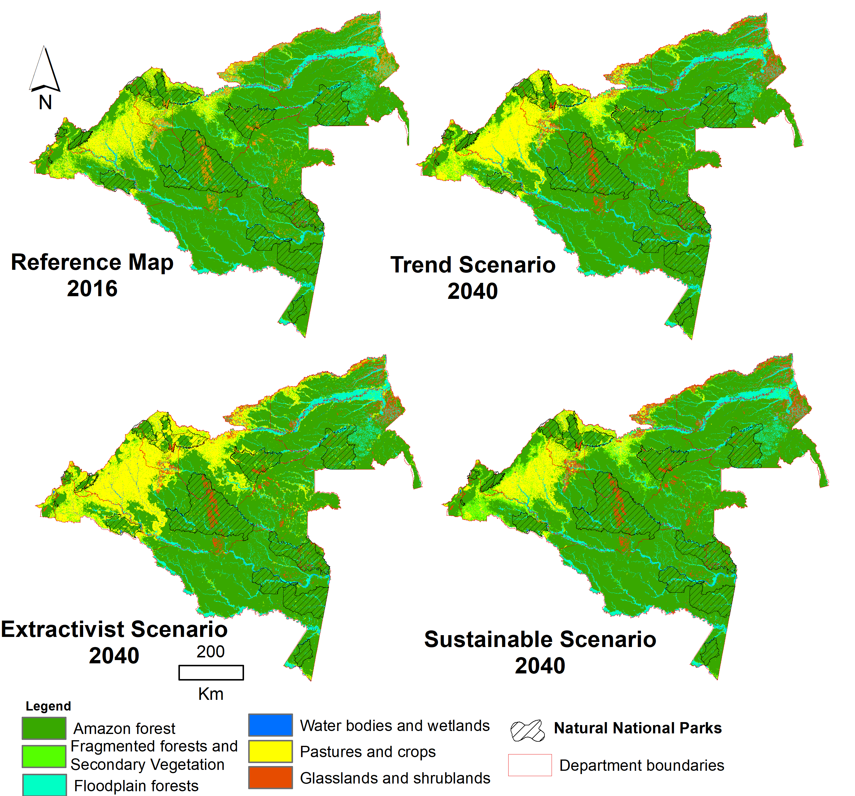
Another article, also recently published in Nature magazine and written by researchers from the Sinchi Amazonic Institute of Scientific Research, revealed that, on average, 190,000 ha (469,500 acres) of new pasture are created in deforested areas of the Amazon every year. “This dynamic of extensive cattle ranching is bringing, on average, one head of cattle for every two hectares,” said Uriel Murcia, coordinator of the Sinchi Institute’s Working Models and Sustainability program and co-author of the study.
The Sinchi Institute’s researchers went further and posited three possible scenarios for 2040. If current levels of deforestation remain the same, the total loss of forest cover in the Amazon will reach 2.1 million ha (5.2 million acres), which could increase to as much as 4.3 million ha (10.6 million acres) if extractivist policies are pursued. On the other hand, if the scale of cattle ranching activities is reduced and sustainable development is achieved, at least 3.5 million ha (8.6 million acres) of rainforest will be saved from deforestation.
Citations:
Murillo-Sandoval, P. J., Kilbride, J., Tellman, E., Wrathall, D., Van Den Hoek, J., & Kennedy, R. E. (2023). The post-conflict expansion of coca farming and illicit cattle ranching in Colombia. Scientific Reports, 13(1), 1965.
Agudelo-Hz, W. J., Castillo-Barrera, N. C., & Uriel, M. G. (2023). Scenarios of land use and land cover change in the Colombian Amazon to evaluate alternative post-conflict pathways. Scientific Reports, 13(1), 2152.
Álvarez, M. D. (2001). Could peace be worse than war for Colombia’s forests? The Environmentalist.
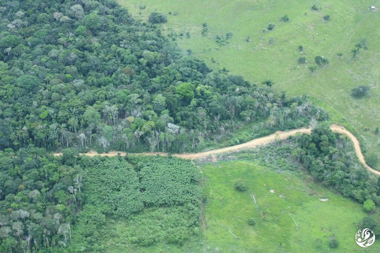
Banner image: Cattle ranching in the Colombian department of Caquetá. Image by Antonio Paz.
This story was reported by Mongabay’s Latam team and first published here on our Latam site on Mar. 20, 2023.
This story first appeared on Mongabay
South Africa Today – Environment
This article is licensed under a Creative Commons Attribution-NoDerivatives 4.0 International License.
You may republish this article, so long as you credit the authors and Mongabay, and do not change the text. Please include a link back to the original article.
