


Traveling today is all about efficiency, accuracy, and convenience. Whether you’re commuting daily or planning an overseas adventure, knowing your way is essential. That’s where Satellite Earth Maps & Live GPS with AI Travel Assistant comes in—a revolutionary tool that blends live satellite imaging, 3D mapping, and AI-powered travel guidance into one easy-to-use mobile app.
From real-time navigation to finding hidden gems in a new city, this app transforms your phone into a global guide that’s available 24/7. Think of it as your personal GPS system, live tour guide, travel planner, and local scout—all rolled into one.
What is GPS Earth Live Satellite Maps & AI Assistant?
It’s a comprehensive navigation app built for the modern traveler. You get high-resolution satellite maps, real-time location tracking, 3D views of cities and terrain, and a friendly AI chatbot assistant that’s ready to help you plan your trip or navigate tricky routes.
Whether you’re walking, biking, driving, or just exploring from your couch, this app offers:
- Instant location awareness
- Voice-activated directions
- Live traffic updates
- Custom travel suggestions from an intelligent chatbot
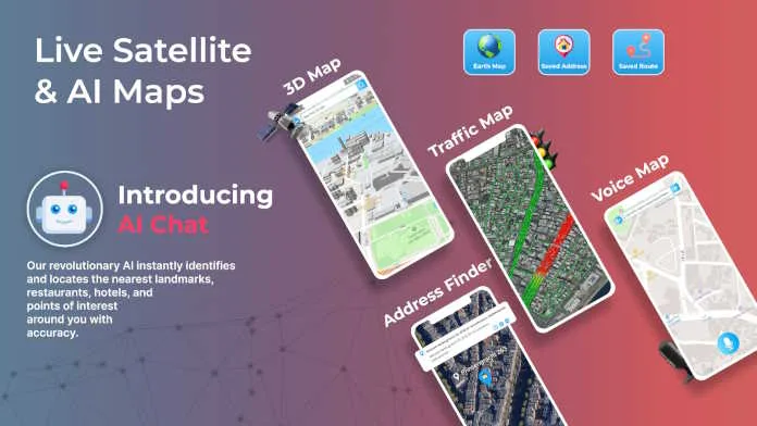
Core Features You’ll Love
1. Real-Time Satellite Maps
Get a bird’s-eye view of any location in the world. With Live Satellite Maps feeds, you can:
- Zoom in on neighborhoods, roads, or landmarks
- Identify buildings, parks, rivers, and more
- Watch weather movements or terrain changes in real-time
Perfect for travelers, students, professionals, or just curious minds.
2. AI-Powered Travel Chatbot
Your digital travel assistant is always ready to help. Just ask the AI chatbot:
- “Where can I find the nearest museum?”
- “Show me the best tourist spots in Dubai.”
- “What’s the fastest route to the airport?”
The bot replies instantly, offering intelligent suggestions, local recommendations, and even weather alerts. It’s like having a human tour guide—but faster and always available.
3. Stunning 3D & Height Maps
Switch to 3D view for a realistic sense of space and elevation. The Height Map feature adds even more depth by color-coding buildings and terrain by height.
Ideal for:
- Virtual explorers
- Urban planners
- Real estate scouts
- Photographers looking for the perfect skyline view
4. Distance Finder Tool
Curious how far your hotel is from the nearest beach? Want to plan a hike? Find Live Location and know the distance. The Distance Finder helps you:
- Measure accurate travel distances
- Get ETAs for walking, cycling, or driving
- Save favorite routes for reuse
No more guesswork—just precision mapping made easy.
Smart Navigation Tools for Everyday Use
5. Voice Maps – Hands-Free and Hassle-Free
Get directions without typing. Speak your destination, and the app:
- Guides you with turn-by-turn voice instructions
- Alerts you to traffic jams or road hazards
- Lets you change routes on the go—all with your voice
Safer driving, smarter walking.
6. Address Finder – Locate Anything Fast
Searching for a café, home, or event venue? The Address Finder:
- Finds any location worldwide
- Shows entry points and street view
- Integrates seamlessly with ride-share or delivery services
Great for tourists, logistics drivers, or anyone in a new area.
7. Traffic Map – Real-Time Road Intelligence
Before heading out, check the Live Traffic Map:
- See red, orange, and green zones for congestion
- Spot accidents, construction, and police alerts
- Let AI suggest alternative routes to save time
Plan smarter. Arrive faster.
Explore the Globe with Ease
The AI chatbot doesn’t just tell you how to get somewhere—it helps you explore what’s worth seeing. From recommending local food joints to creating a full-day city tour, it curates travel experiences for you.
Discover:
- Landmarks, hidden spots, scenic routes
- Cultural attractions and outdoor activities
- Real-time reviews and ratings
It’s like having a smart travel blogger built into your phone.
Discover Nature with Satellite-Level Precision
Heading outdoors? The app is ideal for:
- Finding hiking or biking trails
- Monitoring mountain paths or coastal cliffs
- Checking live terrain and elevation before you go
Whether you’re into national parks or off-road exploring, GPS Earth Live Satellite Maps ensures you never lose your way.
Why It’s Different From Other Navigation Apps
Most GPS apps help you reach a place. This one helps you experience it.
Here’s what sets it apart:
- Live satellite imaging instead of static maps
- AI chatbot integration for human-like guidance
- 3D visuals & height mapping for realistic travel previews
- User-friendly design for all ages and devices
No ads. No confusion. Just clean, smart navigation.
Built for Everyone—Not Just Travelers
- Daily commuters: Avoid traffic and save time
- Delivery drivers: Pinpoint drop-off spots with ease
- Tourists: Get guided routes and sightseeing ideas
- Nature lovers: Discover and plan off-the-grid adventures
Even if you’re not traveling far, you’ll love the everyday convenience of this app.
What’s Coming Next?
The future of GPS mapping is bright—and this app is ready for it. New features include:
- Augmented Reality (AR) navigation overlays
- Offline smart assistant capabilities
- Green route planning to reduce emissions
- Crowdsourced travel updates from other users
More features. Less stress. Better travel.
Conclusion: Your Smart Travel Companion Awaits
GPS Earth Live Satellite Maps with AI Assistant redefines how we travel, explore, and connect with the world. Whether you’re finding your next adventure or just avoiding a traffic jam, this all-in-one tool delivers everything you need—live, smart, and stress-free.
Get started today and see your surroundings like never before.


