


- A team of scientists has monitored the movement of 47 silky sharks (Carcharhinus falciformis) tagged with satellite trackers in the Galápagos Marine Reserve off Ecuador.
- They observed that the sharks travel longer distances than previously known and spend long periods of time in unprotected areas that have a high degree of illegal, unreported and unregulated fishing.
- This leaves them vulnerable to fishing pressure, the researchers say. Silky sharks are the second most commonly sold species in the international shark fin trade.
- Although governments are expanding and connecting protected areas in the region, experts say better management of the oceans and of fishing is needed to save threatened shark species from extinction.
Silky sharks are one of the most widely sold species in the international fin trade. A Mongabay Latam investigation revealed that in 2021 shark fin exports from Ecuador tripled compared to the average of the previous eight years and that the fins of silky sharks (Carcharhinus falciformis) were among the most popular.
These results match those of a 2020 scientific study that identified which species the fins in the markets of Hong Kong and Guangzhou, China, came from. After analyzing the DNA of 12,000 fin samples, the scientists concluded that around 90 shark species are traded but five dominate the business: blue sharks (Prionace glauca), followed by silky sharks, then scalloped hammerheads (Sphyrna lewini), smooth hammerheads (S. zygaena) and shortfin mako sharks (Isurus oxyrinchus). The last four are all threatened species on the IUCN Red List.
According to a press release from Save Our Seas Foundation, a philanthropic organization that carries out scientific research, “[f]ins from up to two million silky sharks contribute to the global fin trade every year.” These sharks face pressure from the fishing industry, which has reduced their populations dramatically, to the point of being considered vulnerable on the IUCN Red List.
To help determine why silky sharks are so heavily traded, researchers from Save Our Seas Foundation’s Shark Research Center and the Guy Harvey Research Institute in Florida, U.S., and the Charles Darwin Foundation in the Galápagos Islands, Ecuador, with support from the Galápagos National Park Directorate, followed 47 silky sharks tagged with satellite trackers. The scientists found that these animals swim in unprotected open seas where there’s a high level of illegal, unreported and unregulated (IUU) fishing.
Where do silky sharks swim?
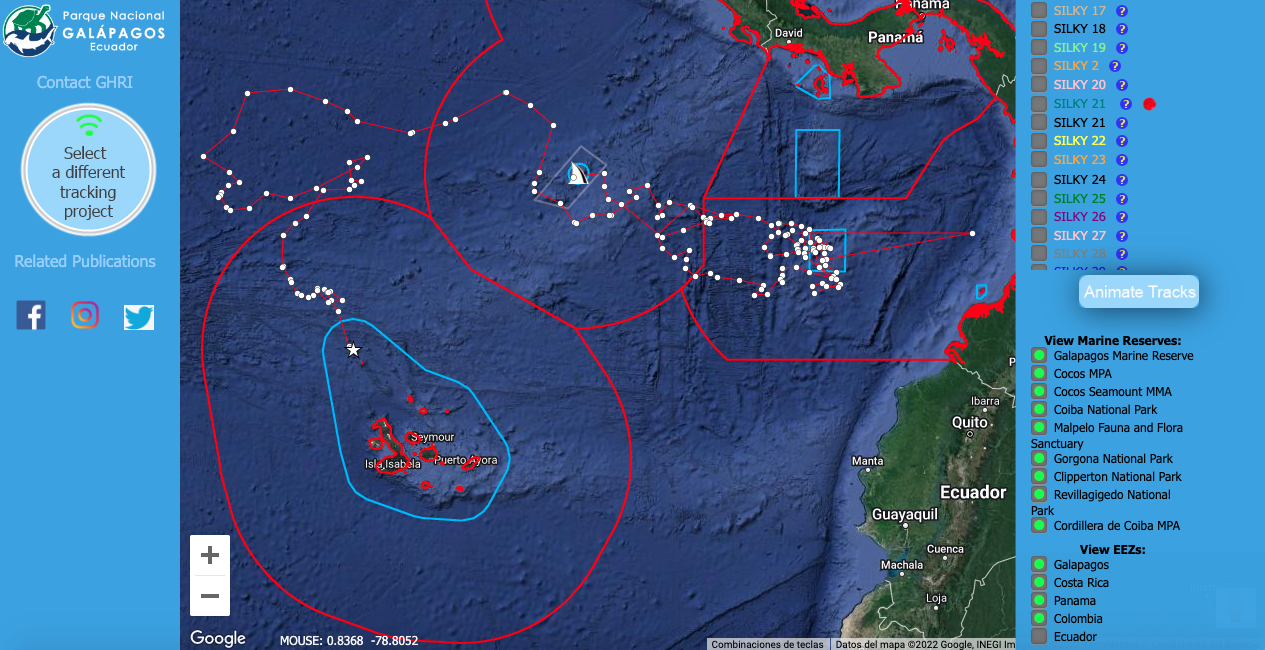
The researchers have followed the movements of the 47 sharks, which they tagged in the Galápagos Marine Reserve, for more than a year. Most of the animals aren’t transmitting their position anymore.
The aim was to understand the silky sharks’ movement patterns and to compare them with areas of high fishing activity to identify where and when the animals are most vulnerable, according to Pelayo Salinas de León, coordinator of marine research at the Charles Darwin Foundation.

“Although most of the 47 silky sharks monitored are adult females, their movement patterns were very different,” says Mahmood Shivji, director of the Shark Research Center.
While some sharks preferred to stay close to where they were tagged, others went for exceptionally long swims. The researchers haven’t been able to determine why there were such big differences. However, the information about what places the animals visited and the distances and depths at which they swam provided important data to be able to better protect the species.
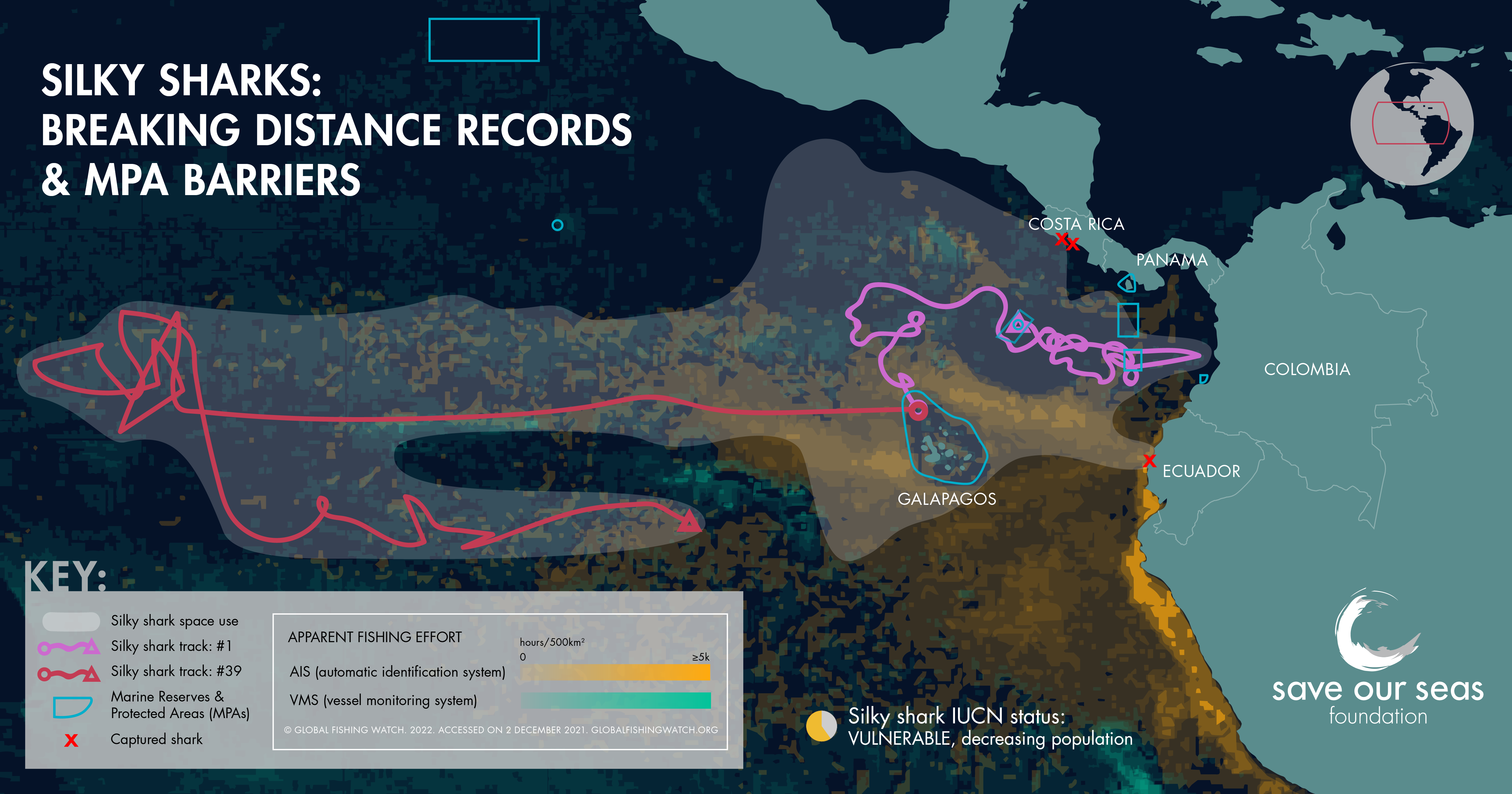
The most surprising data came from Silky 39, a female that traveled 16,300 kilometers (10,100 miles) in 10 months, first westward from the Galápagos Marine Reserve and then back east, approaching the Peruvian coast. It’s a record distance, as the longest ever recorded previously for a silky shark was 11,500 km (7,100 mi) in the Indian Ocean. That proves these animals can swim longer distances than scientists had thought.

As Silky 39’s journey shows, these animals often swim in unprotected areas.
Silky 1, for example, swam 7,000 km (4,350 mi) in seven months and visited marine protected areas in Cocos Island, Costa Rica, and Malpelo, Colombia, in addition to the Galápagos in Ecuador. However, like Silky 39, it spent much of its time outside of marine protected areas and in places where it could have been captured incidentally or deliberately by industrial fishing fleets. In the open seas west of the Galápagos, a big international fleet operates, along with a Chinese squid-fishing fleet that gets close to the Galápagos exclusive economic zone between May and July.
The investigation also shows that although silky sharks swim at depths of more than 300 meters (about 1,000 feet), they spend most of their time in shallower waters of less than 100 m (330 ft) because they tend to feed in tuna schools. According to the Save Our Seas Foundation press release, which describes this research, this habit “renders them extremely vulnerable to industrial fishing.”
The scientists determined that three of the 47 tagged sharks were captured. “We noticed because the satellite tracking tags started transmitting on land for a long time,” Salinas de León says. “The wet/dry sensor in the tag was also telling us that the transmitter was outside of the water.” Two of the captured sharks ended up in a port in Costa Rica and the third one in Ecuador.
Creating marine corridors
During the COP26 climate summit in Glasgow in 2021, the presidents of Colombia, Costa Rica, Ecuador and Panama signed a declaration to establish a marine corridor in the eastern tropical Pacific Ocean that expands the current marine protected areas — Malpelo in Colombia, Cocos Island in Costa Rica, Galápagos in Ecuador and Coiba in Panama — and connects them to each other.
Connecting all these conservation areas with corridors that are also protected is fundamentally important because many species move through these marine havens.
In January 2022, Ecuador created the Hermandad Marine Reserve, which expands the Galápagos Marine Reserve and connects it with another protected area that the government of Costa Rica created in 2021, the Bicentennial Seamounts Marine Management Area, which will include areas closed off to fishing and strengthened fisheries management. This new protected area surrounds Cocos Island National Park, which the Costa Rican government also expanded to protect 53,000 square kilometer (nearly 20,500 square miles) where fishing and other extractive activities are fully banned.

Panama was the first of the four countries to move forward with the initiative: In June 2021 it nearly quadrupled in size the Cordillera de Coiba Managed Resources Area. That expansion allowed that marine protected area to connect with two adjoining Colombian protected areas: the Malpelo Fauna and Flora Sanctuary and the Yuruparí-Malpelo National Integrated Management District.
Together, these expanded and connected marine protected areas protect more than 500,000 km2 (193,000 mi2), an area the size of Spain. “This expanded marine protected area could increase protection for sharks on a critical marine migratory route. But does it go far enough to protect sharks that we now know travel much further than previously thought?” the Save Our Seas Foundation press release asks.
“The expansion of existing marine protected areas and the establishment of new ones are definitely steps in the right direction,” Salinas de León says. “However, highly mobile species like sharks don’t know where the lines on a map are and they just follow their most basic instincts to find food, reproduce or just hang out.”
For that reason, he says, “the protected marine areas by themselves won’t be enough to save the threatened shark species from extinction.” The answer, according to Salinas de León: “There’s an urgent need for ambitious and complete international management to improve governance in oceans, including fishing, to reduce the constant reduction of [the shark] populations.”
Banner image of a silky shark. Image © Pelayo Salinas/Charles Darwin Foundation.
Citation:
Cardeñosa, D., Fields, A. T., Babcock, E. A., Shea, S. K., Feldheim, K. A., & Chapman, D. D. (2020). Species composition of the largest shark fin retail-market in mainland China. Scientific Reports, 10(1), 12914. doi:10.1038/s41598-020-69555-1
This story was reported by Mongabay’s Latam team and first published here on our Latam site on Aug. 11, 2022.
This story first appeared on Mongabay
South Africa Today – Environment
This article is licensed under a Creative Commons Attribution-NoDerivatives 4.0 International License.
You may republish this article, so long as you credit the authors and Mongabay, and do not change the text. Please include a link back to the original article.
