




- Fossil fuel exploration off the northeast coast of Brazil presents a greater cumulative risk of oil spills than previously expected, according to new modeling.
- Seagrass meadows and deep-water reefs in the Potiguar Basin are at greatest risk, as well as portions of the coasts of Ceará, Rio Grande do Norte and Amapá states.
- As the Brazilian government is pursuing rapid expansion of oil exploration in the region, researchers recommend prioritizing preparedness for emergencies where pollution would likely spread, and expanding Marine Protected Areas (MPAs) in low-risk areas.
- Campaigners worry that MPAs might restrict local fishing communities or be implemented too slowly.
In late August 2019, fishing communities along the northeast coast of Brazil reported black oily stains washing up on beaches, with crude clumping between the roots of mangroves, on the shells of turtles and on growing numbers of beached fish.
The origin of the spill was never confirmed: Then-president Jair Bolsonaro first blamed a Venezuelan tanker, then Greenpeace. What was soon clear, however, was the scale of the disaster. Carried by strong winds and ocean currents, by early 2020 the oil had contaminated thousands of kilometers of coastline across all nine Brazilian states in the region.
As the country’s government issued its first oil exploration licenses off the northeast coast in two decades earlier this year, research published last month looks to predict the scale and spread of a potential future spill. According to the study, outdated marine habitat maps and a failure to consider expansion across multiple sites in the region has led officials to underestimate the environmental risks of oil spills, especially for seagrass meadows and deepwater corals. Regions where a spill is more likely to happen should prepare an emergency response, the paper recommends, while “areas of high conservation importance but relatively lower oil spill risk” could be targeted for new or expanded Marine Protected Areas (MPAs) as a precaution.
“Most of the licensing just looks at one activity in one location: not the whole seascape,” Rafael Magris, an ecologist at the Chico Mendez Institute for Biodiversity Conservation and lead author of the research, told Mongabay in a video interview. “We wanted to look at the whole picture in the region,” he said.
The Equatorial Margin, a subsea shelf following the north and northeast Brazilian coast, contains five sea basins that stretch from the states of Amapá in the north to Rio Grande do Norte in the south, of which three border the Amazon River’s mouth. Brazil plans to grow its oil production by a fifth by 2030, and Petrobras estimates the region contains 10 billion barrels of oil.
Combining ocean models with updated habitat maps, the researchers predict that seagrass meadows and deep-water reefs in the central basin of Potiguar off the state of Rio Grande do Norte are most at risk from spills at different exploration blocks in the region
The analysis joins mounting alarm over the environmental consequences of drilling in the region.
While ExxonMobil and TotalEnergies are already extracting in waters off Guyana and Suriname to the north, Brazil awarded state oil company Petrobras an exploratory license for one of its blocks in October. President Luiz Inácio Lula da Silva’s administration opened 19 more blocks in April.
In another study also published last month, researchers calculated that a spill in the Equatorial Margin could contaminate the territorial waters of neighboring French Guiana in as little as a few hours, and the Caribbean Sea within two weeks. A spill in the region could reach as far as Florida, according to a Greenpeace report. “Any spill would be a diplomatic problem as well,” Mariana Andrade, an oceanographer and campaign director at Greenpeace Brazil, told Mongabay in a video interview.
How likely is a spill?
Brazil’s state oil company Petrobras, which has described the Equatorial Margin as “a new offshore frontier,” told Mongabay in a written statement that it has been working in the region for more than half a century, where it has already drilled more than 700 wells. “The company operates with the best safety standards in the industry and throughout this time has never recorded an event that caused damage to the environment,” spokesperson Ludmilla Brandão wrote.
The actual risk of a spill has been raised by Brazil’s environmental department Ibama. At first, officials rejected all six of Petrobras’ wildlife protection plans (which describe plans to manage potential spills), before approval was pushed through under political pressure. In a technical note from 2025, Ibama analysts described the risk of a spill as “unprecedented” because of the Equatorial Margin’s depth, strong winds and currents.
“[Developers] say there is no spill risk, but the idea here is to at least know what can happen in case [of a spill],” Magris said, adding that the modeling only considered spills at the ocean’s surface, and not at the seafloor, and did not account for how the oil interacts with wind, waves and weather.
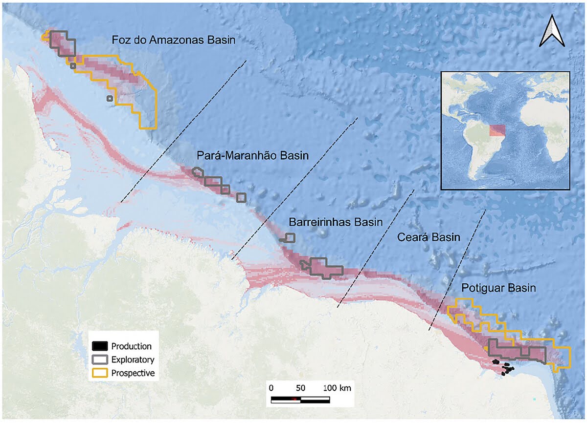
Future research should focus on these more complex models, he said. Because it does not account for weathering or underwater leaks, this study likely still underestimates the full risk of spills, he added.
In January 2026, Petrobras paused drilling in the Foz do Amazonas Basin on the Equatorial Margin after confirming a “synthetic drilling fluid” leak. The following month, Ibama fined the company 2.5 million reais ($485,000) for the incident.
Expanding protections
The Equatorial Margin is home to several critical ecosystems, with seagrass meadows and coastal mangrove forests offering nursery grounds for almost 500 seafloor marine species, as well as unique hybrid manatees and several turtle species. The deepwater or mesophotic corals along the Margin make up the Amazon Reef, which was first formally described in a 2016 research paper and thought to support much of the biodiversity of the Caribbean Sea.
But when Magris and his team started to model the environmental risk of an oil spill, they found that many existing habitat maps were out of date, some underestimating the extent of reef-building corals by 550 kilometers. “People care a lot about the Amazon in Brazil. But because this is the ocean we feel like it’s not accessible, even to fishing communities nearer the coast. It’s an undiscovered area,” he told Mongabay.
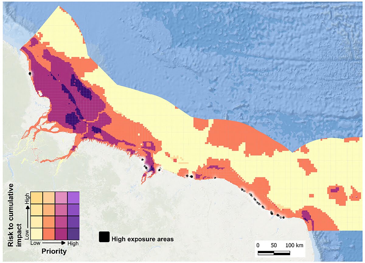
“My biggest concern is that [each licensing decision] seems like a small step — one oil block in the middle of nowhere — but if it goes ahead, it’s going to be really hard to justify why all these other areas shouldn’t also be explored,” he said. “It will open the door and all of a sudden we’ll be in a different reality.”
The researchers argue that new or expanded MPAs would force regulators to analyze the environmental consequences of new licenses more carefully. Magris acknowledged that MPA planning is slow-moving but said that made the need to push for designations more “urgent.”
For some local campaigners, MPAs are not quick enough and do not offer coastal communities protection from the industry’s expansion.
“In practice, we think that judicial action is more effective than mitigation,” Kerlem Carvalho, oceans coordinator with Indigenous rights group Arayara Institute told Mongabay in an email. The presence of oil drilling, whether or not it causes a spill, threatens to “compromise food security, exacerbate migration and affect traditional practices” in local fishing communities, she said, who become squeezed by rising prices as the industry grows in nearby urban centers.

Greenpeace Brazil’s Andrade added that any MPA that imposes a blanket ban on fishing also threatens to disrupt local livelihoods. “We don’t want an MPA that limits the activity of fishing communities that live in the region. So we need a community-led process, and that takes time,” she said.
Shortly after Petrobras was awarded an exploratory license for the Equatorial Margin in October 2025, Greenpeace, Arayara and six other local campaign groups and fishing organizations filed for a federal injunction to block drilling. No decision has yet been reached.
“We are not exploring commercially any oil in the region yet, so we can stop this before it starts — before it becomes a national problem and a problem for other countries,” said Andrade. “I have to hope that we will be able to stop before an accident that could compromise the whole region … but right now we don’t see anything on the horizon that is equitable and really values the region and the people that live there.”
Banner image: A deepwater mesophotic reef in the Equatorial Margin, captured during a video at 100-meters’ depth. Image courtesy of Alexis Rosenfeld/Olivier Bianchimani/Greenpeace.
Citations:
Lessa, G. C., Teixeira, C. E. P., Pereira, J., & Santos, F. M. (2021). The 2019 Brazilian oil spill: Insights on the physics behind the drift. Journal of Marine Systems, 222, 103586. doi:10.1016/j.jmarsys.2021.103586
Magris, R. A., Marta-Almeida, M., & Lentini, C. A. D. (2026). Projected risks to biodiversity conservation along Brazil’s Equatorial Margin under expanding offshore oil development. Conservation Letters, 19(3), e70049. doi:10.1111/con4.70049
Marta-Almeida, M., Lentini, C. A. D., Mendonça, L. F. F. de, Aguiar, A. L., & Lima, A. T. da C. (2026). Vulnerability of Atlantic Equatorial Margin and Caribbean Sea to oil exploration in Northern Brazil. Energy Reports, 15, 109358. doi:10.1016/j.egyr.2026.109358
Moura, R. L., Amado-Filho, G. M., Moraes, F. C., Brasileiro, P. S., Salomon, P. S., Mahiques, M. M., … Thompson, F. L. (2016). An extensive reef system at the Amazon River mouth. Science Advances, 2(4), e1501252. doi:10.1126/sciadv.1501252
Santos, T.; Baia, E.; Santos, A. P., & Venekey, V. (2026). Benthic Biodiversity of the Brazilian Equatorial Margin: A Systematic Review With Recommendations for Conservation Priorities and Research. Boletim Do Museu Paraense Emílio Goeldi – Ciências Naturais, 21(1), 1-34. doi:10.46357/bcnaturais.v21i1.1097
FEEDBACK: Use this form to send a message to the author of this post. If you want to post a public comment, you can do that at the bottom of the page.
Cite this article
Daniel Shailer (2026). Brazil’s expanding offshore oil frontier puts biodiversity at risk: study. Mongabay Conservation news. DOI: https://doi.org/10.66709/news-322398
Credits

This story first appeared on Mongabay
This article is licensed under a Creative Commons Attribution-NoDerivatives 4.0 International License.
You may republish this article, so long as you credit the authors and Mongabay, and do not change the text. Please include a link back to the original article.